


Text and photos with courtesy of hathitrust hathitrust.org, compiled by motorracingistory.com.
THE AUTOMOBILE – Vol. 8, No. *, May 2, 1903
Examination of the Gordon Bennett Race Course in Ireland.
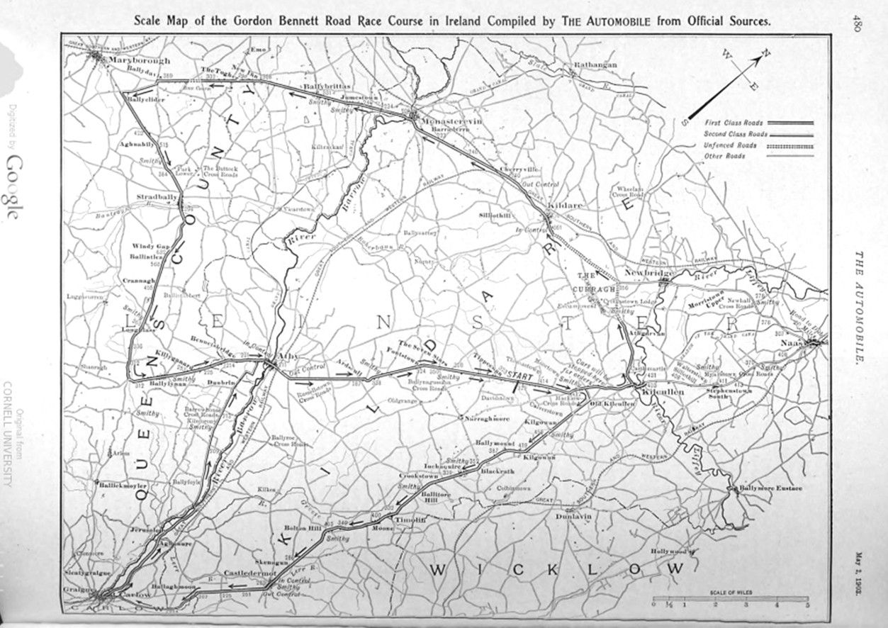
Measurements of the Irish course finally selected for the Gordon Bennett Road race have been made by a special committee consisting of Claude Johnson, secretary of the British Automobile Club; S. F. Edge, winner of the race last year, and Messrs. W. G. D. Goff and R. J. Mecredy, of the Irish Automobile Club. The measurements show that the total distance to be covered by each car in completing the „figure 8“ is about 102 miles, made up of 56 miles 1,540 yards over the larger loop and 45 miles 440 yards over the smaller. By consultation of the accompanying map, redrawn by our cartographer from military maps of the locality and data issued by the British Automobile Club, the course of each car in the race can be readily followed.
MAP OF THE COURSE.
On this map the character of the roads is shown by the use of different lines, which are explained in a memorandum at the top right-hand corner of the map. The figures along the route are altitudes, all being referred to sea level, and therefore a close approximation of any grade can readily be made by taking the difference of the figures between any two or more points, in feet, for the rise and by using the scale at the bottom of the map to ascertain the horizontal distance.
Each car will go around the „figure 8“ three times and around the larger or western loop once in addition. The accompanying unofficial tables give the approximate distances between points and the total mileage to be covered in the race. At the four controls the neutral ground to be traversed has been laid off with regard to the local conditions, as to houses and turns, so as to safeguard the contest-nts. The distances within controls are, in round numbers: Castledermot, 600 yards; Carlow, 1,000 yards; Athy, 1,700 yards; Kildare, 2,500 yards.
THE STARTING POINT.
At the Ballyshannon cross-roads the grand stand will be erected and here the start and finish of the race will be seen. From this point a clear view of the approaching racers can be had for about 2 1-2 miles, and after passing they will be in sight for considerably more than a mile. At this point also the cars will pass more frequently than at other portions of the route, as an inspection of the map will readily show. This location is so situated also that it can be easily approached by visitors coming down from Dublin. They will leave the Great Southern and Western Railway at Kildare and can drive their cars‘ over the seven miles to the grand stand enclosure at any time during the day. In doing so, the course is crossed only once, and as this crossing is within the Kildare control, it can be made without risk or interference. On the side of the road opposite the grandstand there will be a public enclosure for which tickets will be sold in London and Dublin.
The contestants will start in the race from the cross-roads at Ballyshannon, on a first-class undulating road, in a north-easterly direction. About two and one-half miles out a sharp turn leads over a rather poor road and stiff grade, past Old Kilcullen to a good road for the drive south to Carlow. At the turn it is stated that the cars will be halted for orders, as here the two loops of the „figure 8“ diverge, those who have already gone over smaller loop continuing on to Kilcullen proper. At Old Kilcullen there is one of the famous Irish round towers in the grounds of a Parish Church. From the start there is a grade to and past Old Kilcullen which reaches its maximum about two miles from the latter, and from there there is a general decline to Carlow, with a few slight rises intervening. The road is good and favorable to the highest speeds. There are few villages of importance along the route between Kilcullen and Carlow. Ballitore is some distance to the right of the course at the hill of that name, and Timolin and Castledermot, through which the course passes, are small settlements, and the latter is a control. There are a couple of sharp turns between Castledermot and Carlow. From the latter the course runs in a northerly direction, following the river Barrow very closely, and though much straighter than the snake-like turnings of that stream, the road is winding until Maganey bridge is reached. There the Barrow is crossed and the course continues on the longest stretch of poor road in the entire circuit to the market town of Athy; this stretch, however, has the compensating advantage of being fairly level. There is nothing larger than a hamlet on the course between Carlow and Athy. At the latter point there is another control, and here the cars, after recrossing the Barrow, turn northeast again for comparatively straight stretch to the starting point. About half-way there is a sharp turn and a bend where the road circles the old moat of Ardscull. The last three miles to the starting point is straightaway, but with a grade intervening. Over this leg of the course the cars will race seven times.
AT THE LARGER LOOP.
Each car has now gone once around the smaller loop and continuing on goes direct to Kilcullen; but, following the new route, does not cross the river Liffey, as originally intended. The larger loop of the „figure 8“ has now been entered upon, and the cars swing in a northwesterly direction over a good road on to The Curragh, famous in history and song. This is a large plain or downs, on which are located an immense permanent military camp, a racecourse and various traces of ancient civilization. The road across The Curragh is unfenced, as indicated on the map, and is up-grade to Kildare. Here the speed will be slackened for another control. Kildare is an interesting old town, possessing a „Round Tower“ and a restored Episcopal Cathedral – St. Brigid’s. After leaving, here the course continues in a westerly direction on a good straight road, with a general dip of the country to the town of Monasterevin. About half a mile beyond the town there is a very bad double corner on a bridge over the Grand Canal. After getting safely over that, however, the contestants will have a fine stretch of good road which, beyond Ballybrittas, passes through a picturesque wood. After the bend at New Inn is passed there is a long up-grade across the Great Heath of Maryborough, a minor edition of The Curragh. The course here skirts a racetrack and is unfenced. To avoid entering the town of Maryborough, a cross-cut is made on a poor bit of road, with two bad angles, to get started on the run south again to Athy. The turn near Ballyclider is an acute angle. The road fork at Aghnahily is the summit of a hill and from here there is a steady drop for about two miles into Stradbally. This is the only town of importance on the road to Athy, the settlement of Ballylynan, further along, being a mere hamlet. From Stradbally the course runs south through Windy Gap, an elevation of more than 300 feet in a mile and a half, and with a good road surface to a cross-road about seven miles distant. There is a down grade for the last five miles of this stretch. At the cross-roads the course runs north and east to Athy, partly down grade, and the last five miles level and straight, and with lots of room for passing. About half a mile to the west of Athy the cars now strike the course a second time, the large and small loops meeting at Hill View House, and thus complete the entire circuit.
According to the report of the Special Committee, there are straight stretches in the course, each exceeding one mile in length, of a total of about 60 miles. Multiplying this total of straight course by the number of times each car will cover it a grand total of 220 miles straightaway out of the entire distance is the result.
Photos.
Page 480. Scale Map of the Gordon Bennett Road Race Course in Ireland Compiled by THE AUTOMOBILE from Official Sources.
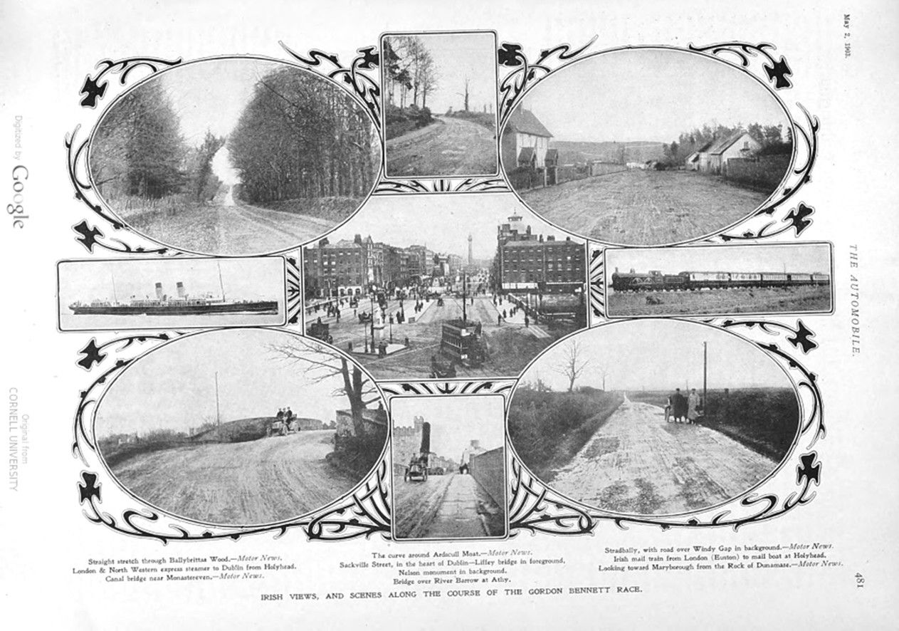
Page 481. IRISH VIEWS, AND SCENES ALONG THE COURSE OF THE GORDON BENNETT RACE.
Straight stretch through Ballybrittas Wood. – Motor News.
London & North Western express steamer to Dublin from Holyhead.
Canal bridge near Monastereven. – Motor News.
The curve around Ardscull Moat. – Motor News.
Sackville Street, in the heart of Dublin-Liffey bridge in foreground, Nelson monument in background.
Bridge over River Barrow at Athy.Stradbally, with road over Windy Gap in background. – Motor News.
Irish mail train from London (Euston) to mail boat at Holyhead.
Looking toward Maryborough from the Rock of Dunamase. – Motor News.